- Sections :
- Business
- Crime & Public Safety
- Local Area
- More
MONTGOMERY COUNTY, Texas - What are the chances of having a tropical disturbance hit the Texas Gulf Coast during the 2016 hurricane season? One of the most significant contributors will be the transition of the El Nino weather phenomenon to La Nina. The last remnants of El Nino producing a strong wind shear, is one of the variables pushing the current tropical disturbance in the Gulf, Topical Storm Colin, towards Florida.
El Nino is characterized by unusually warm ocean waters in the tropical Pacific which provides its strength. In just the last few weeks sea surface temperatures have dropped which indicates a transition to a weaker La Niña condition according to Patrick Blood, meteorologist with the National Oceanic & Atmospheric Administration (NOAA).
“This weaker system will allow tropical disturbances to build, instead of being sheared off in the upper atmosphere by the stronger El Nino winds,” said Blood..
Paradoxically, it’s the warm water in the Gulf of Mexico that lends itself to creating the catalyst, for storms spawned off the west coast of Africa, to build momentum after they cross the Atlantic and enter the Gulf. La Nina will allow the storms to intensify.
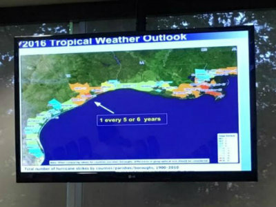
It’s been eight years since this area has experienced a hurricane, Hurricane Ike in 2008 was a Category 2, and thirty-three years since a major hurricane,,,a Category 3, which was Hurricane Alicia in 1983, For the 2016 season NOAA is forecasting a total of 14 named storms, eight hurricanes, and three major hurricanes, based on current weather variables and cyclical patterns.
Blood explained that the unknowns are what are difficult for NOAA to predict.
“We know the knowns, and we know what the unknowns are, but what we don’t know, is what we don’t know.” explained Blood.
It’s unknown how many of the storms will make landfall and where, and what unforeseen variables could also be a factor. Doppler radar now enables the Hurricane Center to better predict where landfall will occur. The ‘cone of uncertainty’ can now be reduced to within a 30-mile band of coastland, and global ocean satellites monitor the globe detecting the storms when they initially form.This significant improvement in tracking capability can provide residents along the coastline, sufficient time to evacuate.
“People along the coast need to be concerned about the storm surge. In Montgomery County the concerns are high winds and the rainfall,” said Blood. “With the current ground saturation, it wouldn’t take much rain for flooding to occur again. One inch of rainfall will cause street flooding.”
Just days into the hurricane season and we already have a storm in the Gulf; in fact, Tropical Storm Colin is the earliest third named storm in recorded history. August is the most likely time that a hurricane might strike the Lone Star State. This is when the water in the gulf heats up, providing a catalyst for storm systems to do likewise.
"We don't know when the Texas Gulf Coast will get hit by a tropical storm, but we do know that it will happen again. Another one of those unknowns," said Blood. "It's not a matter of if, but when."
To see a brief video overview of the 2016 hurricane season by Patrick Blood, click on: The likelihood of a tropical storm or hurricane during the 2016 season
Also see related link with more information about the 2016 hurricane season:
As monsoon season ends hurricane season begins June 1
To view NOAA’s chronological list of Texas tropical storms and hurricanes see:
#BePrepared